megalithic structures above the Weapon Strapatente
(Orco-Feglino, Finale Liguria)
Author: Alfredo Pirondini
Summary
Describes the finding megalithic, its location, its orientation and its relations with neighboring structures of archaeological interest and archaeoastronomical. A brief discussion on the possibility of using the findings described.
Description
Weapon (in Ligure this term has the meaning of "Cave" ) Strapatente is a karst cave, which crosses from side to side above the ramparts and consists of Boragni da un alto ed ampio tunnel naturale che sale da ovest ad est: dal versante che sbocca in Val di Nava a quello che raggiunge il pendio della Val Sciusa.
Lungo il decorso della caverna vi sono grandi stalattiti, stalagmiti, colonne (formatesi dalla fusione di stalattiti e stalagmiti) e piccole diramazioni secondarie.
L'ingresso orientale guarda su un ampio anfiteatro ingombro di massi crollati dalla volta della caverna stessa.
E 'right on top of a rocky outcrop, which extends further east into the Val Sciusa, about 30 feet above the eastern entrance, which is the megalithic structure in question.
The coordinates, obtained by a GPS device, are:
Altitude: 348 m asl; Latitude: 44 ° 12 ' 41.508''North Longitude: 8 ° 21'1, 008''East
The existence of this structure has long been known (7). It must, however, the work of Mario Codebò of 1997, a systematic description of this artifact (3).
The site is located in the Municipality of Orco - Feglino, near Finale Ligure, Savona Province, Liguria, Italy) and can be reached by following the path of the ridge east of the Valley Nava. And 'thanks to the specifications of Mario Codebò that I could find it and restore it as filled with a tangled vegetation.
Advancing along this path, covers the entire ridge east of the Val di Nava reaching above the eastern entrance of the amphitheater Strapatente previously described. Along this route, we find two stone tablets of the Finale that seem to indicate the route. Also visible is a pile of stones that, in light of recent interpretations have a significance of places of worship of the dead from the late Bronze Age.
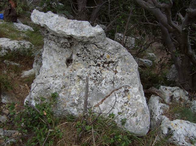
reaching the eastern end of the plateau, the steep valley Sciusa, lies the megalithic structure that has the characteristics of a "stone - altar."
This artifact is, in fact, a horizontal table, is quite irregular, Stone End of approximately 1.5 meters per side, presenting pelvis in two adjoining surface, resting on five stones small. Below the table there is a room (1.2 m, 0.17 m wide and 0.5 m high) oriented in a north - south
The rudimentary pelvis on the surface of the horizontal beam, could be the meaning of "shells" for the collection of liquids. Let us recall, as reported in numerous studies that point to what is described in the sanctuary of Panoias, in northern Portugal where, beside a large rock pools, channels and pans, there is the following Latin inscription dating from the third century. AD (6):
"HVIVS HOSTIAE QVAE CADVNT HIC IMM (OL) ANTVR EXTA INTRA QVADRATA CREMANTVR CONTRA-SAN (GV) IS LAC (I) CVLIS (IVXTA) SVPERFV (NDI)-TVR "
(Here are devoted to the victims who are killed: their insides are burned in the square tanks and their blood is spread in small basins surrounding).
The presence of large rocky outcrops with similar characteristics to those described for the sanctuary of Panoias, is present in the Finale, and in the adjacent valley fossil Nava, both Ciappo ( The term "Ciappo" in the Finale, points to a stone slab) of gigs to Ciappo of Ceci and Ciappo to the Salt (to cite only the most extensive and popular) and you may think that they, at least for a while, had a similar function.
The fact also that the "stone-altar" is built on a high place indicates, probably, will choose a site appropriate from which you could have some sort of visual inspection of the land below, also in relation to the sacredness of the hill stations and mountain peaks typical of the Ligurian-Celtic populations.
Nearby are petroglyphs etched a "sigmoid" namely "they Italic" oriented and engravings, and stone slabs polished and grooved difficult to date.
Another significant finding is the presence of the pile of rocks described above, which can not convincingly correlate with falls of dry stone walls, however, not present here, and even how to get free outcomes (11) for agricultural activities that would be almost impossible, given the harshness of the rocky terrain and the difficulty of water supply.
In these circumstances, given the very similar morphology between this mound and the one cited by Codebò near the Dolmen Verezzi (2), (3), (4), (5 ) with any other of Western Liguria, nelle vicinanze di Sanremo (provincia di Imperia), l'ipotesi più probabile è quella relativa al possibile uso funerario di questi cumuli (1). Sicuramente questa ipotesi dovrebbe essere confortata dal ritrovamento di qualche reperto che la avvalorerebbe. Ciò comporterebbe la necessità di iniziare una campagna archeologica che potrebbe rivelarsi di esito incerto, vista l'esposizione completa agli agenti meteorici, tipica dei siti archeologici “all'aperto”, comuni nel Finalese (8), (9), (10), (12).
Discussione
The dating of the finds described is a difficult problem, as the petroglyphs are located in a place "open", easily modified by meteorological and human factors.
The creation of megalithic structures, such as menhirs and dolmens, is placed, in fact, over a period of time between the end of the fifth millennium at the end of the third millennium BC, corresponding roughly , for a period between the Neolithic Age to the Bronze age.
The clarity and depth of the cuts on the nearby stone artefacts, suggests, however, that have been obtained with metal tools, presumably dating from the Iron Age that, in Liguria, was developed between 900 and 180 BC .
Bibliografia
-
ALESSI C. Sanremo (IM). Archaeological sites in Monte Bignone. Archeomedia - Journal of Archaeology Online ( September 2009). http://www.archeomedia.net/tutela-e-salvaguardia/36475-sanremo-im-siti-archeologici-a-monte-bignone.html -
Codebò M., archaea-astronomical Some Hypotheses on Ligurian Engravings "Proceeding NEWS95 - INTERNATIONAL ROCK ART CONGRESS, North East West South
1995 Turin, Italy, by Ce.SMAP & IFRA, 1999 Survey supplement, Pinerolo, Italy. -
Codebò M. 1997: Archaeoastronomy PRIME INVESTIGATIONS IN LIGURIA, Published on the memory of the Italian Astronomical Society - Journal of the Italian Astronomical Society, vol. 63, No. 3, 1997 -
Codebò M. 1993. The menhir of Torre Bastia. CAI News, Sec. Ligure, Sottosez. Bolzaneto, 11: 30-31. -
Codebò M.1994, the first steps of a Archeostronomo. Bulletin of the Astronomical Observatory of Genoa, n.66, Genova, pp. 12-20. -
Corpus Inscriptionum Latinarum (CILII, 2395). -
GIUGGIOLI O. (1984). A construction megalitica a Finale. In: Rivista Ingauna ed Intemelia, XXXIX, -
PIRONDINI A. 2010. Osservazioni su un sito di interesse archeologico nei pressi del Castelliere delle Anime (Rocca di Perti - Finale Ligure). TRACCE Online Rock Art Bulletin h ttp://www.rupestre.net/tracce_php/modules.php?name=News&file=article&sid=43 -
PIRONDINI A. 2010. Castelliere of Verezzi - Hillfort in Italy in Liguria. The Megalithic Portal. http://www.megalithic.co.uk/article.php?sid=26775&mode=thread&order=0 -
PIRONDINI A. 2010. Site near Finale Ligure. The Megalithic Portal. http://www.megalithic.co.uk/article.php?sid=26588 -
Schipani R. DE PASQUALE, F. Riccobono (1991). Original use of materials' for get free "in the suburban area. In: Archaeology and Astronomy Colloquium Int AA.VV., RDA, Supplem. No 9. Rome. -
Tizzoni M. 1975. Outdoor Engraving in Finale, Liguria. Bulletin of the Center Camuno Prehistoric Studies, 12, Capodiponte (Brescia).

L'anfiteatro dell'Arma Strapatente con l'Altare

Coppelle sulla tavola dell'Altare

Coppelle sulla tavola dell'Altare

La Pietra Altare

Orientation N / S

Shells on the table of the Altar

Shells on the table of the Altar

stones upon which the panel of

stones upon which the panel of

stones upon which the panel of

groove

Stone slotted

Stone crucible and grooved along the path

"T" along the path

Stone slotted

Stone slotted
Stone with engravings oriented and sigmoid
© Alfredo Pirondini 27/09/2010


